Nigerian Gas Flare Tracker
Satellite gas flare tracking from 
Nigerian Gas Flare Tracker
Satellite gas flare tracking from
The primary data source for the Gas Flare Tracker is the Visible Infrared Imaging Radiometer Suite (VIIRS) on board the Suomi National Polar-orbiting Partnership (S-NPP) satellite.
The VNF product data used to locate gas flare sites and estimate the volumes of gas flared is from the EOG at mines.edu.
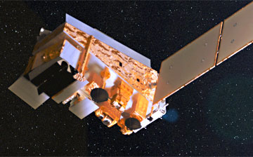
The satellite flaring data presented here comes from the VIIRS Nightfire (VNF) data product, developed and produced by the Earth Observation Group (EOG) at the Colorado School of Mines. Every 24 hours, a new VNF data set is produced, with locations, temperatures, source sizes and radiant heat form infrared emitters worldwide. VNF are produced from VIIRS data from the U.S. National Oceanic and Atmospheric Administration (NOAA).
The Gas Flare Tracker downloads this data for Nigeria and removes readings with temperatures below 1400 degrees kelvin. A calibration method outlined below is then applied to this data.
Get the VNF data from the EOG at mines.edu
References:
Elvidge, C. D., Zhizhin, M., Hsu, F -C., & Baugh, K. (2013).VIIRS nightfire: Satellite pyrometry at night. Remote Sensing 5(9), 4423-4449.
Elvidge, C. D., Zhizhin, M., Baugh, K. E, Hsu, F -C., & Ghosh, T. (2015). Methods for global survey of natural gas flaring from Visible Infrared Imaging Radiometer Suite Data. Energies, 9(1), 1-15.
Elvidge, C. D., Bazilian, M. D., Zhizhin, M., Ghosh, T., Baugh, K., & Hsu, F. C. (2018). The potential role of natural gas flaring in meeting greenhouse gas mitigation targets. Energy Strategy Reviews, 20, 156-162.
Do, Q-T, Shapiro, J.N., Elvidge, C.D., Abdel-Jelild, M., Ahne, D.P., Baugh, K., Hansen-Lewis, J., Zhizhin, M., Bazilian, M. (2018). Terrorism, geopolitics, and oil security: Using remote sensing to estimate oil production of the Islamic State. Energy Research & Social Science.
Elvidge, Christopher D., Morgan D. Bazilian, Mikhail Zhizhin, Tilottama Ghosh, Kimberly Baugh, and Feng-Chi Hsu. "The potential role of natural gas flaring in meeting greenhouse gas mitigation targets." Energy strategy reviews 20 (2018): 156-162.
Elvidge, Christopher D., Mikhail Zhizhin, Kimberly Baugh, Feng Chi Hsu, and Tilottama Ghosh. "Extending Nighttime Combustion Source Detection Limits with Short Wavelength VIIRS Data." Remote Sensing 11, no. 4 (2019): 395.
The assumption underpinning the Gas Flare Tracker is that nothing burns as consistently hot in the same isolated location as a gas flare.
The Gas Flare Tracker isolates clusters of VNF estimates above 1400 degrees kelvin. Multiple temperature readings above this level in the same area are assumed to be the location of a gas flare site.
Mscf is an abbreviation of one thousand standard cubic feet of gas. It is the industry standard for measuring natural gas volumes.
The VNF algorithm cannot make accurate measurements when there is excessive cloud cover. Cloud cover is prominent for much of the year in the Niger Delta, and therefore the VNF data available is a partially complete picture of the gas flaring that goes on beneath the clouds.
The very high accuracy of VIIRS Nightfire in quantifying gas flaring volumes is outlined in Elvidge et al's VIIRS Nightfire: Satellite Pyrometry at Night 2013.
Read the paper - VIIRS Nightfire: Satellite Pyrometry at Night
The 'presumed operating company' information, found in the 'Gas Flare Locations' map layer, assigns presumed company responsibility to gas flare locations. This was generated manually by cross-referencing named oilfield geometries (from the google map dataset linked below) with those listed in NNPC's 2014 and 2015 annual reporting bulletins. The 'presumed operating company' information is indicative only and not empirical.
No party involved with any data available on this website take any responsibility for the accuracy of the information made available or the use of that information by any third party.
The calibration method used by the Gas Flare Tracker System to calculate gas flare volume estimations from VNF radiant heat estimates is based on this comparison of reported flare volumes and VNF derived estimates.
Once we have an estimate as to the volume of gas in Mscf (Mscf is thousand standard cubic feet of natural gas) then calculating other metrics is a simple linear equation:
53.12kg of C02 are emitted for every Mscf of natural gas burned. Reference
Gas value is based on an average gas price of $3.50 per Mscf. Reference
Penalties are based on a Nigerian penalty for gas flaring of $2 per Mscf. (Please note that each gas flare penalty calculation is based on a flat rate of $2 per 1,000 mscf for the volume given. However, according to Nigerian regulations, this rate applies to relevant concessions producing more than 10,000 barrels per day of oil. Below this threshold, the penalty is $0.50 per 1,000 mscf. At present, the Gas Flare Tracker does not differentiate between production volumes. As such, the actual penalty due may differ, for this and other reasons.) Reference
Power generation potential is based on 0.0003 GWh per Mscf with a gas power station turbine efficiency of 33%. Reference
Average electricity usage per capita per year in Nigeria is estimated at 130kwh. Therefore one Mscf equals to the energy useage of 2.27 Nigerians electricity consumption for a year. Reference
The volumes and quantities of gas flaring displayed on this website, and the companies these are assigned to, are estimates based on available data and should be seen as indicative and not empirical.
No party involved with any data available on this website takes any responsibility for the accuracy of the information made available or the use of that information by any other third party.
Parties wishing to disclaim or contest the information displayed are invited to provide their own alternative data to NOSDRA.
© All photos Copyright Ed Kashi 2014.

This product was made utilizing VIIRS Nightfire (VNF) nightly data produced by the Earth Observation Group, Payne Institute for Public Policy, Colorado School of Mines.
This initiative is managed by NOSDRA. It was created by Stakeholder Democracy Network with geospatial analysis by WebGeospatial and software development by Sentido-labs.